Travel-Maine.Info
|
Main Menu
Home
Blog
FALL
Fall Foliage
Apple Orchards
Halloween
Hunting
Thanksgiving
WINTER
Alpine Skiing
Nordic Skiing
Snowmobiling
Ice Fishing
Dogsledding
Snowshoeing
SPRING
Maple Syrup
SUMMER
Biking
Birding
Seacoast
Whitewater Rafting
Kayaking
Camping
Hiking
Fishing
Summer Camps
Windjammers
THINGS TO DO
Vacation Planner
Shopping
Places to Visit
Recreation
Forts
Lighthouses
Museums
HELPFUL PAGES
Cities & Towns
Maine Blogs
Maps
Maine News Media
Books about Maine
Business Directory
Business Services
Real Estate
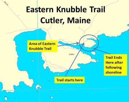
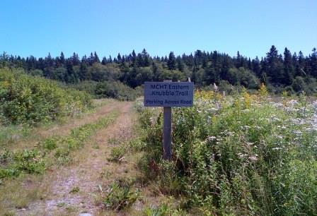
Eastern Knubble Trail
Cutler, Maine
Home >Seacoast > Eastern Knubble Trail in Cutler, Maine
The wooded promontories of
Eastern Knubble and Western Head enclose the entrance to the harbor of
Cutler, Maine village. The
Eastern Knubble, of approximately 30 acres, was acquired by the Maine Coast
Heritage Trust (MCHT) several years ago.
This trail travels along the shoreline of the northern shore of Little River in Cutler, Maine. The path is well-maintained and exists on a plot of land that is densely wooded. The summit of Eastern Knubble rises to 151 feet; however the trail sticks to the shoreline. There is no marked path to the summit. The village center of Cutler is 2.6 miles away. To the south of Eastern Knubble one can see across the Little River the Western Head Preserve (another Maine Coast Heritage Trust preserve).
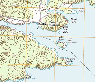
Topo Map of Eastern Knubble 1/24,000 by USGS
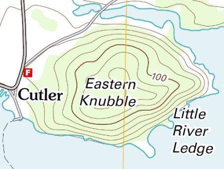
Eastern Knubble Map
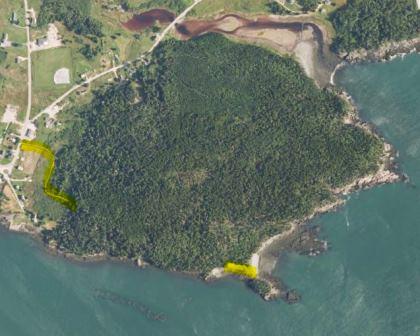
Beginning and end of trail marked with yellow. (USGS)
Map showing location of Eastern Knubble Trail. Town of Cutler Property Map. The Eastern Knubble Trail is at the far east point on along the northern shore of the Little River on this map.
http://cutlermaine.net/Cutler_Map3_sm_zone_4_5_10.pdf
Topographic Map by topozone.com of Eastern Knubble Trail
www.topozone.com/map.asp?lat=44.6572&lon=-67.1958&s=50&size=s
Topographic Map by Topoquest.com.
www.topoquest.com/map.php?lat=44.65730&lon=-67.19526 . . .
Google Map of Eastern Knubble, Cutler, Maine.
http://goo.gl/maps/LxXuT
Shoreline Zoning Map for Cutler, Maine - Univerisity of Maine, 2009.
http://digitalcommons.library.umaine.edu/towndocs/244/
The trailhead is located on Route 191 just next to the Cutler Post
Office and Volunteer Fire Department. There is parking across
the street (Route 191) from the Post Office.
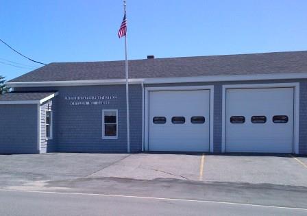
The Cutler, Maine Post Office and Volunteer Fire Department
is on
Route 191. The parking lot for the Eastern Knubble Trail is
across the street from the Post Office. The trailhead is located
just to the south (right) of the Post Office building.
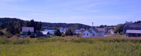
A view of Cutler, Maine as you start your journey on Eastern Knubble Trail
The trail starts off in a field but quickly moves into dense woods.
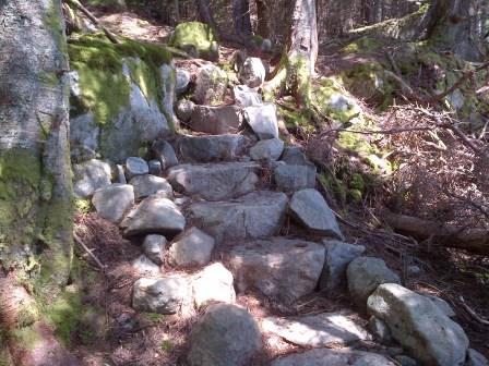
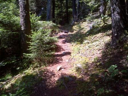
The Eastern Knubble Trail is well-maintained as
seen in this photo of a stairway made with stones along a steep area. Work on the trail is done by crews for the Maine Coast Heritage Trust (MCHT).1.
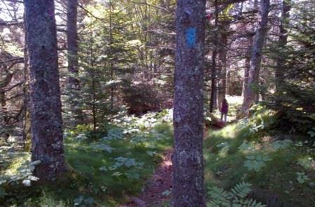
The Eastern Knubble Trail is marked with blue
paint so you
will find it hard to get lost or loose your way along the path.
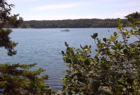
At many points along the path you parallel the
shore and catch
an occasional glimps of a lobster boat in the Little River.
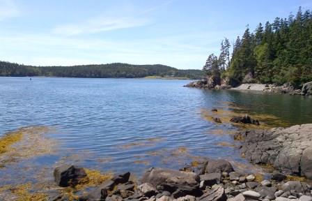
At the end of the trail you can view the Western
Head Preserve
located across the Little River
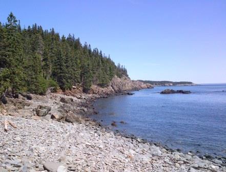
East View of Maine Coast from end of the Eastern
Knubble Trail.
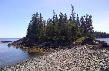
This small Island found at end of Eastern Knubble
Trail is referred to on some maps as Little River Ledge. At this point, after exploring the little island, your hike is over and you double back along the same trail to Route 191. Someone more adventorous might try
to find a way to the top of Eastern Knubble (there is no known path).
Blog Posts, News Stories, Magazine Articles,
and other Information on Eastern Knubble Trail
Eastern Knubble Summit Info by MountainZone.com.
www.mountainzone.com/mountains/detail.asp?fid=7771956
Endnotes
1. For more information on trail work crews of the Maine Coast Heritage Trust see Work Crew Improves MCHT Preserves, MCHT, October 2011.
www.mcht.org/news/2011/10/work_crew_improves_mcht_preser.shtml
Home > Seacoast> Eastern Knubble Trail - Cutler, Maine
|
|
AdsThe website is an Amazon Associate and earns money for qualifying purchases.
|
|
|